 |
||
| Quick Business search | Site Wide Search | |
Langebaan
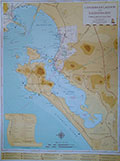 |
The Langebaan Lagoon Map The Langebaan Lagoon Map is now available at selected stores in Langebaan and Saldanha. For more details about this map, click here |
Langebaan is close enough to Cape Town for weekenders to enjoy the beauty of the town and far enough for locals to enjoy the peace and tranquility of a village life.
Langebaan is world famous amongst water sport enthusiasts. During the year Langebaan hosts various International water sport events. Some of the world's best kite surfers prefer Langebaan to practice their sport.
For nature lovers there is the Weskus National Park and Langebaan is one of the most popular destinations during flowering season.
For gamblers there is the Club Mykonos Casino.
Nearest
Towns: Saldanha and Vredenburg
From Cape Town: About 130 Km
THE HISTORICAL BACKGROUND OF LANGEBAAN
Langebaan is one of the oldest and well-known West Coast towns. The Langebaan lagoon reaches southwards for 17km behind the Atlantic Coast, from Saldanha Bay in the north to Geelbek in the south. It is 4km wide in places and is well-known for its white mussels, birds, beautiful flowers during spring (August to September) and the Postberg Nature Reserve. Postberg is known for its flowers and game, including black and blue wildebeest, bontebok and eland. The park originally existed of 300 hectares, but was later extended to 27 600 hectares. The park includes Preekstoel and fishing communities such as Kraal Bay and Churchhaven. The historical Geelbek farmhouse has been converted into a centre for environmental education. Birdlife is abundant on the islands of Jutten, Malgas and Marcus. Langebaan is situated 124km from Cape Town.
The name Langebaan is according to tradition a result of one of three legends. [1] Before World War II fishermen flecked the fish they caught and put it on to wooden panels (bane) at the high water mark. [2] During the 17th century fjords were called bane in the Dutch language. [3] The town had its origin on the farm De Stompe Hoek, originally known as Geitenmelksfontein. According to belief the long, winding road behind sand dunes, from the original farmhouse (The Lodge) to Leentjiesklip gave the town its name. Leentjiesklip, a caravan park, was named after a runaway sailor called Lynch. Earlier it was called Lynch Point. Fossils found on the farm Elandsfontein, in 1953, traced Langebaan’s origins to a period ten million years ago. Langebaan was also meeting place of the Khoi leaders.
Langebaan’s modern history runs parallel to that of Saldanha Bay. The bay got its name in 1601 when a Dutchman, Joris van Spilbergen, mistook it for the place where Antonio de Saldanha landed in 1503. De Saldanha actually landed in Table Bay. Early in the 17th century, French seal hunters used Schaapen Island to store skins and oil. A lot of the seafarers used the safety of the bay to repair their ships. The director-general of the French East India Company explored the bay in 1648 and named it the islands.
During 1662 Jan van Riebeeck sent scouts to the bay. Their negative report about the lack of fresh water however made him loose interest in the area. The bay was only used to provide the Cape with fish, eggs, and birds and to keep sheep on Schaapen Island, for the use of passing ships. Lions and other predators did a lot of damage. Tracks and skeletons of rhinos, elephants and hippos were also found on the islands. Salamander Bay was named after a ship which arrived in the bay to provide its sailors, who was scurvy, with fresh food. From 1658 free burghers started moving to the bay. To stop them bartering with foreign ships, the company built Oude Post (Kraal Bay) with a small garrison. In 1666 six men were sent to protect Oude Post and the islands from French annexation. They built a fort and in 1669 the garrison was enlarged to 15. Admiral de la Haye and his fleet invaded the bay in 1670. He took over the fort and arrested the garrison and a few burghers. After a few days he released everybody and departed. Not long afterwards the Khoi, under leadership of Kees, raided the fort and killed 4 men. The unrest persisted until 1677. In this time quite a few pirates made the bay their home. Geelbekfontein was the first official farm and was awarded to a free burgher in 1729. In 1732 Oude Post was moved 2km north and gardens planted.
With the First British Occupation in1781, the Dutch and English battled it out in the bay. One of the leaders of the 1820 Settlers took over Oude Post and the Company moved their post to Oostewal. Mr. Parker later returned to England, because he could not keep up with his payments. The area remained quiet until the guano rush in 1844. For the next few years hundreds of ships stripped the islands of guano, and lawlessness was the order of the day. An English warship was stationed in the bay to keep order and taxes were levied on the guano.
During 1870 Salamander Bay was used as a quarantine station for sailors with infectious diseases. Through the years the islands were frequently used for sailors suffering from scurvy. Now camps were erected, with tents, to keep the sick away from the Cape. The cemetery at Salamander Bay is witness to the smallpox epidemic of 1882. By 1893 the camps were closed, but they were reopened during the Anglo-Boer War when there were outbreaks of bubonic plague and smallpox.
In 1909 John Bryde opened a whaling station at Donkergat when Greenland whales became scarce. His 3 whale-catchers were the start of a modern South African whaling fleet. Shortly after this Carl Ellefsen opened a factory at Salamander Bay. The whalers had great success and during the closed season they repaired their boats and equipment. The scarcity of whale-oil made prices rise drastically during the First World War. In 1926 a big fire started when 2000 barrels of whale-oil exploded. The factories survived, but had a lot of competition from other factories on the South African Coast. The Great Depression of 1930 brought an end to whaling. The town stated to prosper and most people made their living from fishing. In 1919 the first town council was chosen.
During the Second World War Saldanha was used as a base for the British fleet. Security was tightened and residents had to carry permits. Big Catalina Flying boats were used to track German submarines. The Catalinas used Langebaan lagoon for loading of provisions and Donkergat for moorings. To observe the weather a meteorological station was erected and this led to the discovery that the air above Saldanha is remarkably free of air pockets. The problem of fresh water was finally solved in 1943 when a pipeline was laid from the Bergriver. The demand for whale-oil during the Second World War let to the reopening of the whaling station at Donkergat in 1947. After a successful season the Salamander Bay station reopened as well. Big companies were started and shares offered to public. After 1967 whales became scarce and international competition was developing. The whaling stations ceased operations. The military took Donkergat over in 1942 and it then became a restricted area.
Langebaan became popular with retired people and as a holiday resort, especially with overseas visitors. On 19 November 1976 the town received municipal status. A lot of the foreign surnames under the local community can be traced to fortune-hunters hoping to make money from whaling
Above information with compliments from The
Farmhouse Hotel